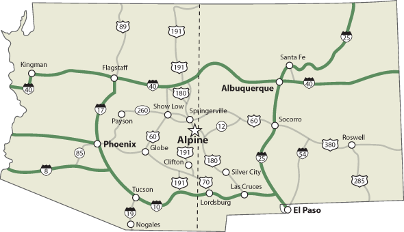
Where is Alpine?
Alpine, Arizona is an unincorporated community in the east central part of the state. Alpine was settled in 1876. It was originally known as Bush Valley. Located at an elevation of 8,050 feet in the eastern end of the White Mountains and surrounded by the Apache-Sitgreaves National Forest. Alpine is a popular destination for hunting, fishing, wildlife and bird watching, and camping. Alpine is near the headwaters of the San Francisco River and 6 miles west of the New Mexico border.

Phoenix to Alpine – 253 miles – 5 hours drive time
- Take the 202 East
- Exit 13 Country Club Drive
- Turn Left at SR 87 N/N Country Club Drive at the end of the off ramp
- Continue to follow SR 87 (Beeline Hwy) to Payson
- At Payson, Turn Right on SR 260 East towards Show Low
- At Show Low, Turn Left at US Hwy 60 East (Deuce of Clubs)
- Continue to follow US Hwy 60 East towards Springerville
- Drive through Springerville
- As you’re exiting town, make a slight right at US 180 E/US 191 S
- From here Alpine is 24 miles south and about 40 minutes away
Tucson to Alpine – 269 miles – 5 hours drive time
- Take the I-10 East
- Exit 352 for US 191 N toward Safford
- Turn Right at US 191 N US 70E
- Turn Left at US 191 N
- Continue straight onto SR 78 East (Entering New Mexico)
- Continue on NM-78E
- Turn Left at US-180 W (Entering Arizona)
- Continue on US 180 until you arrive in Alpine
Albuquerque, New Mexico to Alpine -222 miles – 4 hours 23 minutes drive time
- Take I-40 West
- Exit 89 towards Quemado
- Turn Left at NM-117 West
- Turn Left at NM-36 South
- Turn Right at US-60 West
- Turn Left at US-180E/US 191 S
- From here Alpine is 24 miles south and about 40 minutes away.
El Paso, TX to Alpine – 272 miles 5 hours drive time
- Take I-10 West/US 85W towards Las Cruces
- Exit 82A toward NM-26/Silver City/Hatch/ US Hwy 180 W
- Merge onto I-10 Frontage Road
- Turn Right at US 180 W/ N Gold Ave
- Continue on US Hwy 180 W to Alpine